
ALERT: Cholera to spread further as 31 states risk heavy flooding – FG
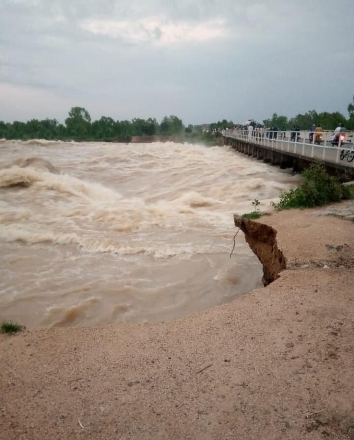
No fewer than 10 states and the Federal Capital Territory, Abuja, had either experienced various degrees of flooding or recorded casualties as rains intensified in the last couple of days.
According to the Minister of Water Resources and Sanitation, Prof Joseph Utsev, who dropped the red alert during a press briefing in Abuja, 21 more states might suffer flooding.
Recall that Wednesday downpour grounded business and commercial activities in Lagos and Ogun states.
The resulting flooding brought down a two-storey building in the Mushin area of Lagos and overwhelmed residents while pupils could not attend schools in parts of the state.
Also, a pupil was swept away by the flooding in the Ketu area of Lagos.

Utsev explained that the Annual Flood Outlook by the Nigeria Hydrological Services Agency released in April had predicted that 148 local government areas in 31 states fell within the high flood risk areas.
The affected states include Adamawa, Akwa Ibom, Anambra, Bauchi, Bayelsa, Benue, Borno, Cross River, Delta, Ebonyi, Edo, Imo, Jigawa, Kaduna, Kano, Katsina and Kebbi.
READ ALSO: Edo Governorship: ‘Ighodalo remains our candidate’ — PDP
Others are Kogi, Kwara, Lagos, Nasarawa, Niger, Ogun, Ondo, Osun, Oyo, Plateau, Rivers, Sokoto, Taraba and Yobe.
The minister warned that cholera might spread further in Nigeria due to the flooding.
He further stated that river flooding would begin this month, and would hit Ondo, Kaduna, Anambra, Benue, Adamawa and 12 other states.
According to him, out of the 31 states where the Annual Flood Outlook predicted would experience flooding, the incident had occurred in 10.
Providing a national update on flooding, Utsev said, “It should be noted that some states have started experiencing varying levels of flooding and its associated disasters as early as April this year.
“So far, more than 10 states of the federation and the FCT have experienced one degree of flooding or the other with several casualties recorded including displacement of people and loss of property.
“For example, the torrential downpour in the early hours of June 24, 2024, in the FCT resulted in flooding of Trade More Estate in Lugbe where two deaths were reported and several houses submerged.’’
He stated, “AMAC (Abuja Municipal Council), Kuje, Gwagwalada, Bwari, and Kwali LGAs (local government areas) have also been flooded. Other affected states and LGAs are Anambra (Onitsha North); Edo (Benin); Benue (Makurdi); Kwara (Oke-Ero, Moro); Lagos (Agege, Alimosho, Ikorodu, Lagos Island, Ikeja, Eti-Osa); Ogun (Ijebu-Ode); Osun (Oriade); Nasarawa (Doma); Taraba (Takum, Sarduna); and Yobe.
“It is important to note that as rainfall increases both in frequency and intensity, particularly in the southern part of the country, this will increase the level of flooding and may worsen the ravaging cholera outbreak.”
According to the National Centre for Disease Control, the cholera outbreak has resulted in 63 deaths and 2,102 suspected cases as of June 30, 2024.
The water resources minister stated that most of the flood incidents recorded so far were flash/urban floods resulting from high rainfall intensities of long duration and poor and blocked drainage systems in the urban areas and their metropolises.
“As of today, both Kainji and Jebba Dams on River Niger are still impounding water into their reservoirs. Shiroro Dam on the River Kaduna is equally impounding water. There is no release of water yet from any of the dams within and outside Nigeria.
“At this point, it is important to state that river flooding is expected, beginning this month (July 2024). The states that are likely to be impacted by this as predicted are Akwa Ibom, Anambra, Adamawa, Benue, Bayelsa, Cross River, Delta, Edo, Jigawa, Kogi, Kebbi, Kaduna, Niger, Nasarawa, Ondo, Ogun, Rivers, Taraba and the FCT,” Utsev stated.
The minister recalled that in April 2024, he presented to the general public the 2024 Annual Flood Outlook by the Nigeria Hydrological Services Agency, an agency under his supervision.
The agency has the responsibility for the provision of information on flood forecasts and alerts and monitoring of all the major rivers in Nigeria, including the trans-boundary Rivers Niger and Benue.
“The AFO shows that 148 LGA in 31 states fall within the High Flood Risk areas, while 249 LGA fall within the Moderate Flood Risk areas with the remaining 377 LGA falling within the Low Flood Risk areas.
“The high flood risk states as predicted are Adamawa, Akwa-Ibom, Anambra, Bauchi, Bayelsa, Benue, Borno, Cross-River, Delta, Ebonyi, Edo, Gombe, Imo, Jigawa, Kaduna, Kano, Kebbi, Kogi, Kwara, Lagos, Nasarawa, Niger, Ogun, Ondo, Osun, Oyo, Rivers, Sokoto, Taraba, Yobe, Zamfara and the FCT,” Utsev stated.
The minister pointed out that Nigeria is located within the River Niger Basin which is occupied by eight other countries including Benin, Burkina Faso, Cameroun, Chad, Cote D’ Ivoire, Guinea, Mali and Niger.
READ ALSO: Climate Change: FG to tax Nigerians on carbon emission
“The country is at the lowest portion of the basin. This means that once the upper catchment of the basin gets flooded, Nigeria should be prepared to experience flooding incidents. It is important to note that the month of June 2024 signifies the beginning of hydrological year 2024/2025 in the Niger Basin.
“The flow situation within the catchment is currently within normal as the rising water levels at our various monitoring stations in Niamey are still within acceptable levels.
“The flow situation at Jiderebode in Kebbi State upstream of Kainji and Jebba reservoirs which is the first monitoring station on the River Niger in Nigeria is still at the normal situation. The same applies to the flow at Lokoja, Kogi State (the confluence of Rivers Niger and Benue).
“We are also monitoring the development on the River Benue Sub-Basin. Here, Wuroboki in Adamawa State is our first monitoring station where the flow from the upstream Cameroun is received. The flow situation at Wuroboki is relatively normal at this time, so there is no cause for alarm in terms of water releases in the Benue River basin.
“The Lagdo Dam operators have informed us that they are currently filling the dam for hydropower generation. However, we will keep monitoring the development on this flank and put close tabs on other monitoring stations as we are approaching the critical months,” he stated.

Comments are closed.